
Resumen
The city of Tangier is the largest urban centre of the Moroccan Mediterranean coast. It is strategically located in one of the few meeting points (or rather proximity points) between Africa and Europe across the Mediterranean Sea, rendering it heavily strategic in geopolitical terms. At the same time, a country that historically had focused its development further south is now seeing its northern regions arise as large and constantly changing urban centres. It has been subject during the last decades to strong migratory movements both from foreign and rural regions, intensely pressuring over its built capacity.
Palabras clave
Actores
Nicole Rochette (Archipiélago), Author
All images are author’s own unless stated otherwise.
Cifras
Año
2013

Tangier. The margins of a city on the edge.
The city of Tangier is the largest urban centre of the Moroccan Mediterranean coast. It is strategically located in one of the few meeting points (or rather proximity points) between Africa and Europe across the Mediterranean Sea, rendering it heavily strategic in geopolitical terms. At the same time, a country that historically had focused its development further south is now seeing its northern regions arise as large and constantly changing urban centres. It has been subject during the last decades to strong migratory movements both from foreign and rural regions, intensely pressuring over its built capacity. These conditions allowed for the condensation of particular urban phenomena which is transversal to most southern Mediterranean cities, mainly regarding the issue of housing large quantities of new urban populations. This issue has been dealt with differently according to the diverse contexts it is confronted with, and in the case of Tangier, the political conditions favoured a vast proliferation of self-built houses extending the limits of the urban realm.

Migration into urban centres. The Mediterranean in movement.
Migration plays an important role in the evolution of Mediterranean cities. The north of Morocco in particular is both a place of immigration and emigration, as migrants from sub Saharan Africa pass through Morocco expecting to reach Europe, representing a significant cultural component of the growth of urban centres. Even more numerous are the internal migrations between rural and urban zones, attracted by the work available in the area. These processes result in an accelerated growth of the urban areas, since the need for permanent residency is confronted with a saturated and degraded urban fabric and insufficient offer of adequate low-cost housing. The areas of the region which are still not urbanised come therefore into tension because of the forces that hover over it, and when the existing urban structures become surpassed by the demands, the territories outside of the urban realm become contested territories.

Migratory routes in western africa. There are many trans-Saharan routes, most of which arrive to Morocco through the city of Agadez. Once across the Sahara, the Subsaharan migrants remain within their Maghrebi societies. Map according to information found in these sources: Overland and maritime migration routes to North Africa, the Middle East and Western Europe / de Haas, Hein (2007): The Myth of Invasion: Irregular Migration from West Africa to the Maghreb and the European Union . International Migration Institute, University of Oxford. L’immigration subsaharienne au Maroc / MGHARI, Mohamed, 2008, Euro-Mediterranean Consortium for Applied Research on International Migration (CARIM).


Sprawl. Urban consequences of a rapid population growth.
Tangier is currently the main destination of migratory movements in the region, and has for the last decades gone through a rapid urbanisation process. After Tangier lost its international status and was annexed to Morocco, the city expanded beyond the limits of the international period, observing an intense population growth precisely while the city did not have any plans or orientations for the development. As
a result, Tangier observed an intense growth, a random expansion resulting in an uneven territory, a city that is polarised between a compact centre and a dispersed periphery. The sense of dispersion is amplified by the topography: scattered pieces of the city attempt to function as a whole in what is an uneven piece
of land, with infrastructures laboriously attempting to connect it and with a noticeable deficiency of basic services.
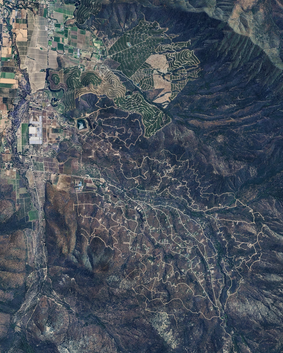
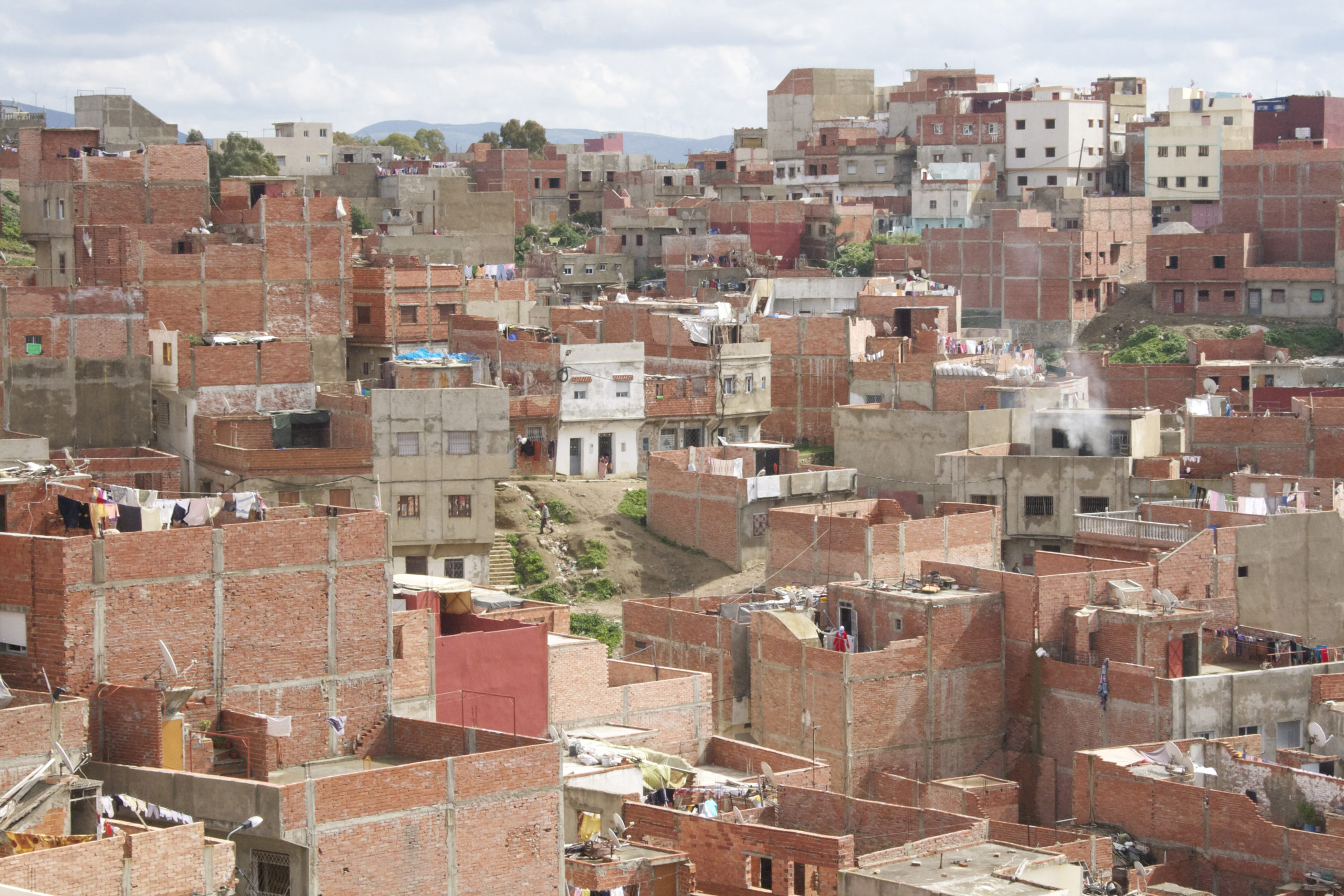
This sprawl, a result of the city bound migration confronted with a saturated and degraded urban fabric and insufficient low-cost housing has put pressure over the preexisting farm land, modifying the periphery of the city in a substantial manner. The authorities have attempted to control this sprawl, mainly through the enforcement of a limit to the urban area, without effectively reducing the rate at which the footprint of the city continues to grow. Within this scenario, a particular type of habitation appears especially marginalised and numerous. The most peripheral and hilly areas are covered with a blanket of single family housing units, with a visible homogeneity.


Non regulatory neighbourhoods. The territory of self regulation
Close to 30% of Tangier is now built through a single typology. It is officially referred to (among other less adequate terms) as Non-Regulatory Housing (NRH). Its advance dates back to the 1970s and presented
a strong growth in the 80s and 90s, and basically consists on a collection of significantly populated neighbourhoods scattered around the city’s hills and former agricultural areas. The logic of addition of single family units into neighbourhoods creates a condition where vast zones are dormitory areas, with a high dependency to the central parts of the city and without network services. These types of constructions are easily recognisable since they share a very particular typology: their typological homogeneity is based upon structural principles, economic logic, and space qualities, together with a common isolation condition and a particular legal framework


Réserves foncières gelées au bord de la route de Tanger (Tétouan, 2003) / Le Tellier, Julien: “Les recompositions territoriales dans le Maroc du Nord”


Low density. The zones where the density is still low have large areas of land which remains undefined. Houses limit directly with this land which usually receives waste and construction debris.


Restructuring process in Houmat Chouk, with an emphasis on the painting of buildings. Mise à niveau urbaine de Haoumat Chouk / Holding Al Omrane


A project on the territory. Responding to a particular logic of production
The non regulatory periphery of Tangier calls for a re-founding project. Continuing to regard these
areas as a problematic or defective share of the city will only extend and accentuate an approach which only focuses on remediating contingencies. While the introduction of basic services and community programmes is a necessary objective, the emphasis should rather be placed on what these interventions can generate in a larger sense. The state has the opportunity of granting a more permanent sense of citizenship than through the mechanical resolution of sanitation and transportation problems, or than the construction of sparse educational, health or administrative facilities. Without undermining the importance of these actions, engaging with a territory of this magnitude obliges to undertake further ambitions regarding the role that these represent within the communities they relate with.
So the question arises as how to address the matter of sprawl in a positive manner, proposing mechanisms that move away from standard – and standardised – procedures. Rather than considering the urban conditions of these areas as a problem that needs to be resolved, how can this territory be problematised?
It is important to stress the fact that the areas in question have been produced through very different political, economic and social processes, and are built over different topographic and terrain conditions than the rest of the city. These particularities allow to recognise them as a territory in themselves, contiguous but different from the pre-existing Tangier. This territory can easily be distinguished from
the rest of the urban footprint, resulting in a polarisation between a more compact centre and a more dispersed (but nonetheless dense) periphery. This relationship can be better articulated as Tangier actually being composed of three different “cities”: the Medina (with its traditional courtyard houses), the French planned city (composed of boulevards and 8 floor buildings), and the non-regulated domain. Each of
these cities has a particular prevailing typology and cultural specificity, while coexisting under a same administrative body. In this regard, Tangier’s recently created Urban Agency published in 2011 a document showing the areas which are “open for urbanization or development” for the entire country. For the Tangier region, the development area reaches up to the urban limit, envisioning large areas for housing and infrastructure projects.
This document however disregards the vacant land contiguous to the non regulatory neighbourhoods, this “middle territory” made up of self-built housing and strong slopes (except for some indications regarding the future restructuring of some areas). The superposition of the existing footprint and the areas destined for development leaves an area of uncertainty that could eventually serve the expansion or continuation of an undifferentiated housing development. Considering the possible expansion areas, what are
today territories in the margins of the city will become the gravitational centre of the formerly peripheral territories. What project can be drawn over such a territory?
Observing the way in which the territory is organised, it is important to note how in a context where there were no planned orientations, the resulting condition is a non oriented, undifferentiated sprawl whose main system of reference is the actual terrain over which it is built. Terrain conditions, together with simple and low cost building techniques, become the main urban guidelines and constraints. At the same time, the scale and density of the non-regulated areas allow to think of them as a separate reality, and
by doing so, imagine a new underlying order for it. Rather than attempting to link them and understand them in relation to the more structured parts of city, what is proposed is a procedure that would allow for a certain autonomy. Whereas the peripheral areas of Tangier appear as a difficult and fragmented area to the inhabitants of the plains, the logic of the topography sheds light on how to approach any kind of intervention within it.
We can look at the existing developments together with the available land around them, and consider the entire resulting surface as material for project, as the problematic itself. When doing this, the particular conditions present in the territory in question become evident. It consists of a collection of hills, of soft but repeating slopes, that host a series of more cohesive settlements. At the same time, the entire area has very little flat land, and any intervention necessarily should deal with the slope as a condition.
A Delaunay projection of the territory (triangulation of the topography) allows breaking it down to its planar components and selecting areas of intervention which are of different surfaces and slopes. The project should be capable of proliferating over the territory, following the growth and densification of housing clusters.
The intention is to propose a new possibility for these areas. The project seeks to create a new scenario where scale and geometry are used in order to generate spaces for the community. Given the real necessity of incorporating elements of civility so to make the area effectively manageable, the action of
the state is reoriented towards providing the basic programmes and services in a more strategic way. Thus, the state not only provides the structures, but also an infra-structure, a new way of understanding the territory and of orienting future development, which is based on the idea of citizenship and allows for spaces of representation to arise. These interventions would represent an anomaly, a moment of exception within the homogeneous fabric, inherently attracting activity and creating points of gravitation.

Non regulatory urban fabric. The grain of non regulatory neighbourhoods is identifiable from above. While some of the neighbourhoods are immersed in the urban footprint, large areas appear completely disconnected from it.


Geographic determinants. The direction that the urban growth took in absence of enforced regulations was heavily influenced by the terrain conditions in these areas. While the flat, secure and easier to develop areas closer to the coast were under stronger control, flood zones, steep terrains and agricultural areas were kept with a looser hand, which gave way to unrestricted construction.


Planned development. The Urban Agency has recently published a document showing the areas which are “open for urbanization or development”, which reaches up to the urban limit but however disregards the “middle territory”, except for some indications regarding their future restructuring. Atlas des zones ouvertes à l’urbanisation, 2011. www.marocurba.gov.ma

Middle territory. The superposition of the existing footprint and the areas destined for development leaves an area of uncertainty that could eventually serve the expansion or continuation of an undifferentiated housing development.


Fragmentation. The area is composed basically and primarily of single family buildings. Very few structures diversify the surroundings.
Citizenship and scale. Spaces for representation
The outskirts of Tangier is a territory composed of the addition of individuals: every single family unit is placed next to the following, in an operation that is repeated in an iterative manner over the topography. The repetition of this simple operation represents both its strength and its weakness, when failing to generate spaces for the resulting collectivity.
As discussed earlier, the state has progressively responded to the situation by incorporating roads, public facilities and networks. The population rightly regards these as a validation from society, and consider
the permanent home water connection as significant of a right of citizenship. However the state has a chance to rethink the way in which it penetrates within these areas of the city, anticipating future needs for management and representation.
The proposal then addresses the development of these peri-urban areas of Tangier, aiming to establish community access to political representation throughout the urban fabric, intensifying or creating local centralities within and between non-regulated neighbourhoods
The strategies within the neighbourhoods differ according to the state of completion and density of the intervened settlements, and the objective is to introduce an urban component that will incorporate new functions and scales in contrast with the predominance of a homogeneous housing environment.


Local administrative office / Health centre / Police station / Post office / Water and electricity services office / Museum of the Rif / Market place / Information centre / Bus station / Hospital / Water wells and distribution centre / Library and multimedia centre/ Shared multifunctional space / Garden/Square / School / Kindergarten / Child care – maternity / Local Radio-broadcasting station / Workshop facilities / Skate park / Commercial centre / Cinema / Crafts centre.


A dialectic approach. The horizontal as a possibility
The proposed interventions propose to introduce a new component into the equation: flat open surfaces that will facilitate community activities. The objective is that the introduction of this urban component will incorporate new functions and scales to otherwise homogeneous housing environments. The creation of a flat surface requires a cut and fill operation, so the retaining wall stands out as the main element through which this new collectivity will be constructed. Understanding the triangle as the minimum geometric surface that defines a plane, two retaining walls are enough to create a planar surface against the topography. The operation is repeated in an iterative manner, proliferating over the territory. This simple repetition of a topographic mechanism which is the dialectic typology from the single family block could
be deployed as a means of evidencing and accentuating the area’s rough topography while conferring an element of cohesion.
The resulting forms integrate the desired programmes within their morphology, merging them into a single functional topology. As a consequence, the surrounding areas are reoriented towards the new activities, redefining circulations and hierarchies of the built form. The project effectively incorporates a wide range of public and private functions based on the location of new local administrative centres.


References
- Amzil, L., Debbi, F., and Le Tellier, J. La Mobilité Urbaine dans L’Agglomération de Tanger: Evolutions et Perspectives. Sophia Antipolis: Plan Bleu, 2009.
- Bekkari, H. Tanger Post Internationale, article in Urban generations : post-colonial cities / ed. by David Richards, Taoufik Agoumy, Taeib Belghazi. – Rabat : Faculty of Letters of Rabat, 2005. – 471 p. : ill., krt. ; 24 cm. – (Publications de la Faculté des Lettres et des Sciences Humaines, Rabat Série: Colloques et séminaires, ISSN 1113-0377 ; 126)
- De Haas, H., International migration and regional development in Morocco. Workshop New Moroccan Migrations, Institute of Development Studies, Sussex Centre for Migration Research, University of Sussex, 13 July 2005.
- de Haas, Hein: The Myth of Invasion: Irregular Migration from West Africa to the Maghreb and the European Union . International Migration Institute, University of Oxford , 2007.
- De Miras, C., Le Tellier J., Gouvernance urbaine et accès à l’eau potable au Maroc. Partenariat Public-privé à Casablanca et Tanger-Tétouan, L’harmattan, Villes et entreprises, Paris, 2005.
- Direction d’Urbanisme de Maroc, “Atlas des zones ouvertes à l’urbanisation, 2011”. Available from www. marocurba.gov.ma
- Haut commissariat au Plan et direction de la Statistique. Recensement général de la population et de l’habitat, [Accessed 24 May 2013]; Available from: http://www.hcp.ma
- Hyunjin, K. The Study and Example of application for the Establishment of Cadastral Methodology in Morocco. TS 5K – Cadastral Projects. FIG Congress 2010 Facing the Challenges -Building the Capacity. Sydney, Australia, 11-16 April 2010. [Accessed 24 May 2013]; Available from http://www.fig.net/pub/fig2010/ papers/ts05k%5Cts05k_kim_4150.pdf
- Le Tellier J., Les Recompositions territoriales dans le Maroc du Nord, doctoral thesis of geography, Aix- Marseille University, 2006.
- Le Tellier, J., Relations sociales et lieux de sociabilité urbaine autour des bornes-fontaines publiques à Tanger (Maroc), in Les lieux de sociabilité urbaine dans la longue durée en Afrique, Fourchard Laurent, Goerg Odile, Gomez-Perez Muriel (éd.), Paris, L’Harmattan, 2009.
- Mghari, Mohamed, L’immigration subsaharienne au Maroc. Euro-Mediterranean Consortium for Applied Research on International Migration (CARIM), 2008.
- Programme des Nations Unies pour les Etablissements Humains –ONU-HABITAT. Evaluation du programme national “Villes sans Bidonvilles” Rabat, 2011. [Accessed 24 May 2013]; Available at http://www.unhabitat. org/downloads/docs/11592_4_594598.pdf